Translate

Sunday, 6 December 2015

Iceland: MYVATN


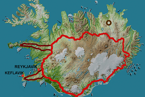
Red is the Ring Road, Myvatn lake is in the brown circle.

Myvatn is a fairly large, shallow lake (lake = vatn) south-east from Husavik.


 We drove to its western shore admiring the scenery along the way. The days in the north were beautiful - no rain, clear skies and fresh early-autumn air. Along the way we admired the Icelandic sheep and horses - both of which we had fallen in love with.


  The lake welcomed us with an amazing scenery so we jumped out of the car more than eager to take some photos. not more than a couple of seconds later the swatting started! We had no idea that "my" in the word Myvatn meant "midge". We arrived to Midge Lake!


Midges are not the blood-sucking monsters but they like moisture so they look for it everywhere they can - in your eyes, nose, ears ..... The lake is quite shallow and relatively warm, ensuring that their numerous offspring will have a good chance to develop and mature. I am sure that the many birds on the lake find the little midges useful but I just could not bring myself to saying the same. So when Lucia bought two the head nets I was the first to ask for one!
You can see that the two riders are wearing them as well.
Aside from the "my" - the midges, Myvatn treated us to something very special. There were a number of special "craters"; beautifully shaped and coloured, with the cute Icelandic sheep grazing their sides and swans swimming about the "craters". This lake is known for the large numbers of birds that take refuge and food in it.


These formations, we learned, were not the real volcanic craters but "pseudo-craters" formed by super-heated jets of hot steam that found their way from the hot sub-layers to the surface. They exploded with such force that they formed funnels - sending the blasts of top soil into the lake. Check the National Geographic site for images better than mine.


The eastern side of Myvatn had another surprise for us. In a stark contrast with the pastoral scenes of the west, this one reminded us more of the Tolkien's Lord Of The Ring.
 

Dark volcanic towers tens of meters high, rose above the vegetation. 
Were we inclined to start believing in "hidden people" such as gnomes, trolls and faeries it would definitely be there - in the Dimmuborga Valley..


How did such towers came to be?
It was a vast lake of burning lava that filled the depression adjacent to the lake. Thanks to the jets of water shooting up from the ground the lava started to solidify around the jets forming the dark towers above. 


Eventually, an obstruction that kept the lava lake contained gave out and the still-hot mass slithered out of the valley. But the towers were there to stay ....


Leaving Dimmuborga behind, we drove north to an entirely different set of natural phenomena. Northern side of Myvatn is in the extremely hot area - that's where we stumbled upon steaming plateaus of Hverir.

But that would lead to another entry in this blog.


Saturday, 5 December 2015

Iceland: North of Myvatn - HVERIR


The Ring Road in red, Hverir and Gunnuhver hotsprings in dark circles.Both are on the tectonic fault.

I hope that I am right to say that "hver" is an Icelandic word for a hot spring.
Remember Gunnuhver?
Having this "vast" knowledge of about 10 Icelandic words these days, I could translate that as Gunna's hotsprings.

As for Hverir - situated exactly on the opposite side of Iceland's continental rift line - I can only say that it is a hot, hot, hot area. A very hot set of hot springs. How is that for a translation?


It all starts at the North end of Myvatn - the midge lake - whose western shores are dotted with pseudo-craters and the eastern ones remind us of Lord of the Ring. Not to be outdone, the north end of the lake presents the traveler with something entirely different. Steam is rising from both, land and water, letting us know that landmass is being split right underneath our feet.

One can tell not only by the rising steam but also by a number of geothermal structures present in the area.

And that is only the beginning.  A chain of low mountain ridges rises towards east - and behind it lie vast mountain plateaus ruled by tectonic forces.
It is there, behind the ridge, that
 Hverir shows off its best.


Some say that this area reminds them of Yellowstone, USA. The steam hisses out of the guts of Earth - 200 degrees celsius and more. The mud bubbles in the dark pools, sending blasts of hot muck into the air. The smells are the same - sulfuric, rotten egg assaults to the olfactory senses.
Yellowstone minus the greenery. No bison, no elk or wolf .....just the raw, steaming and bubbling Earth!
Downright humbling to a human being and a "must to do" experience.


Famous Krafla, the volcano, reigns to the North, not far from here.
If, or rather when, it awakens again Hverir will change to something else.


Iceland: The North - Húsavík

The Ring Road in the red, Husavik is the dark circle.

A beautiful fishing and touristy town of the North! It is large compared to many other town - a whooping 3000 or so. It has a lot going on there - aside from fishing. It is quite famous for its museums and whale watching tours.

How to get there? Simple. Just follow the Ring Road signs.
Make sure not to speed even if you are worried about the accommodation that had been booked on the internet a long time ago.
the fines are rare but steep.

They will make sure that you get your bed for the night.


We managed to beat the night by only about an hour. Just threw our stuff into the hotel room and took off to explore and eat. This was one of the first findings - roses in September some 50 km South of the Arctic circle! For us?


Find # 2:
A1952 snowmobile made by the Canadian company - Bombardier (eh?) .... what a gem of a machine!


Find # 3:
A display on the side of a building lures us in.
And astronaut museum - dedicated to the Apollo astronauts who came to Iceland to hone their rock-collecting skills. 9 of the 12 who came here in 1967 ended up walking on the Moon.


Find # 4?
FOOD!!!!
Just as the darkness fell we walked into a fish-serving restaurant featuring the catch of the day.
And the experience? Oh, sooooooo good!


There is nothing like a splash of bright colours on a foggy morning!

Just like the astronauts half a century ago, these people wore their thick, protective gear with purpose and pride.

The brave souls willing to jump into an inflatable boat to be carried onto the open vastness of the Arctic seas.
Why?


For a chance to get a glimpse of a whale - of course!


We, "the elders", along with many younger ones, decided to do just the same except - we would take the BIG boat!
We would be much safer and the ride would be easier on our stomachs, we believed.
(Yes, you can start laughing NOW if you wish.)

In any case - the whales present at that September the 5th glorious day would be a Minke and a Humpback - if.....if they decided to feed and show off for us. Just like the one on the poster by the ticket office.


If not, we would could just visit the whale museum down the road.


Our whaling trip started with laughter a anticipation as our beautiful  "pirate" boat took off onto the open water.

They would take us some 3 km OUT there - past the mountain ranges of the bay - into the blue space all around us made only by the water and the sky. 30 more km and we would touch the Arctic Circle.

 But then the swells started to rise ....


Many of us lost interest in the whales - it was the survival instinct that kicked in - and it went straight from the heads to the stomachs. Many a fish got well fed that day.

But we did see some whales and at the end it was a trip to remember in a positive way. There is something about those giant mammals that draws the human race in - less and less for their flesh, more and more for their companionship. Perhaps one day we will figure the reasoning of that.

I could not help but to think of the poster in Reykjavik.


 A Minke whale showed up - feeding in different spots, then a Humpback at the end of our 3-hour trip.

I am sure that many have much better photos than mine - but for us it was the time never to forget.

And the next time?
Pack some Gravol and have a couple the night before ....

Look straight at the horizon .....

Do not ....

You know ....

Do whatever works for you but go.


Iceland: WATERFALLS OF THE NORTHEAST


 DETTIFOSS , SELFOSS, HAFRAGILSFOSS

The Ring Road in red and the waterfalls in NE - dark circle.
This plateau reminded us of Sahara desert.
Bare and strewn with sand, gravel and boulders it seemed to lead to nowhere ... but the pylons of rocks served as a reminder of trails leading the traveler to a destination we knew nothing about.
As we drove on the tundra changed too - lichens and mosses disappeared and all was left was bare rock.
  Waterfalls? Here?


But then....there it was! The interpretation sign for Jokulsargljufur National Park!
Until a few years ago this park used to be its own entity  but now it is a part of the larger Vatnajokull NP to the South of here.

That's where the river - Jökulsá á Fjöllum 
(jokul=glacier, a=on, fjöllum=mountains) - originates before making its 200 km way to the North.


On it, a map the river, the canyon and the faults - meaning -the WATERFALLS!


The red dot on the left meant the parking lot. It was time for a hike!


The walk to the falls was quite easy as long as one wore a wind jacket and a pair of good hiking boots or sneakers.

Whatever vegetation there was, it kept a low profile, crouching on the south-facing sides of the larger boulders.

It was easy to imagine the glaciers of the past slithering across the plains, their unimaginable mass obliterating the boulders to the meek, flat surfaces.


The shapes of the rocks were also something to study - from the rounded ones to the sharp edged cubes or columns, all that depending on the properties of the rock. 
One could spend hours admiring and recording the environment offered by this tortured subarctic plateau.


But the wind and rain prompted us on. Our walk took perhaps half an hour before we got a glimpse of a rainbow.

A waterfall?


The river,  peaceful as it made its way through the flat countryside, had been channeled into a series of deep canyons. Roaring mad it hurtled down with and unimaginable force and speed - creating one of the largest and the most powerful waterfalls in all of Europe.


They named it Dettifoss.
The falls could be accessed from either side of the canyon - and if  you look closely at the photos you will be able to detect people on the opposite side, some  100 meters away.


According to Wikipedia:

 Dettifoss drops into the Jökulsárgljúfur canyon, a feature which, along with the Ásbyrgi gorge, appears to have been formed by catastrophic glacial flooding caused by volcanic activity. The volcano in question was possibly Bárðarbunga, which has been identified as posing the risk of a similar event in the future.

It was coincidental that at the time of our Sep 2014 travel, Bárðarbunga awakened underneath the glaciers of Vatnajokul NP, threatening to chew its way up to the surface and disrupt its surroundings once more.


Just a short way up from Dettifoss roared its smaller brother - Selfoss. Less compact but just as impressive, it was one of the three. Pity that we did not have time to visit Hafragilsfoss, the one down the stream.


Same trails that led us to the canyon delivered us safely back to the parking lot.  It was from there that we stole the one last look back.

Just then the skies lit up in the pastel colours of rainbow.


Bardabunga volcano calmed down after a few months. But it is still rumbling underneath the solid wall of Vatnajokul's ice. Dreaming of the future - and when it gets its way it might change this countryside again. 
Only the time will tell.